Common Language Location Identifier (CLLI): MLFRMIQ0010
Thanks to Ken Hoehn for contributing this information.
Address: Off Kensington Rd. in Livingston County, MI
Latitude: N42-33-23 (42.55639)
Longitude: W83-41-41 (-83.69472)
Elevation: 1184 ft. (361 M)
City/County of License: Milford/Livingston, MI
Active Callsigns: None
Canceled Callsigns: KVU87
Located on high ground known locally as "The Bluffs", Milford's principal structures are a 387 ft. (118 M) self-supporting steel tower and an equipment building, which includes a large addition.
Milford was a major microwave junction, serving Detroit and surrounding areas. The station had no long-distance cable connections - all traffic was carried by radio. Milford operated in the 4, 6, and 11 GHz common-carrier bands.
Although Milford's equipment supported thousands of AT&T long-distance circuits, no local telephone service was available at the station until about a year after its construction. Milford's local lines were not provided by a Bell System company but rather by GTE, in whose territory the station is located.
Milford was intended to be a remote receive (part of a "voter" system) site for the Detroit VHF/UHF mobile telephone system in its earlier days. A radio cabinet, antenna, and transmission line were installed but GTE didn't provide the needed landline circuits, so the equipment was never activated. The antenna is now used for a ham-radio repeater.
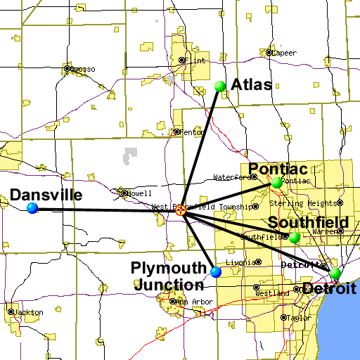
Milford's last microwave route, linking Dansville and Plymouth Junction, was turned down in mid-1994.
From January 1970 or earlier, until the early 1990s, Milford had microwave links to the following stations:
Atlas was a microwave junction linking Milford with Flint, Pine Run, Millington, Dryden and Oxford.
Dansville was a relay station, just northwest of the small town of Dansville, linking Milford and Potterville.
In downtown Detroit, AT&T and Michigan Bell Telephone (later Ameritech) shared two adjacent 19-story buildings collectively known as "Detroit Bell". The office at 1365 Cass Avenue (on the corner of Michigan and Cass) was constructed before the 444 Michigan Avenue structure; the buildings are connected at most floor levels. There were antennas on both buildings; most of the AT&T antennas were on the 444 Michigan building or on the wall of the 1365 Cass Building. All Michigan Bell offices and AT&T's regional offices were housed there. A 150 ft. monotube tower on the roof supported whip antennas for VHF and UHF radio services, and the buildings had a number of steel support structures for microwave horns.
As at many Bell System offices in major cities, architectural details were given great attention; for example, each floor's elevator lobby has a different style of marble.As the city's principal Bell System facility, Detroit Bell contained housed many types of equipment supporting a wide range of communications services. Five full Electronic Switching Systems (ESSs) provided local telephone service. Backup power was supplied by five turbine generators. Special services included 37, 42, 150, and 450 MHz mobile telephone, the 454 MHz Detroit Air/Ground Mobile Radio System, the Detroit Maritime Radio System, 158 MHz paging, and the 451 MHz Telephone Maintenance Radio Service.
Many technicians were based at Detroit Bell, some of them assigned to an Alarm Center which monitored Michigan Bell facilities in the area. And the office employed a large number of operators, who assisted callers from Traffic Service Position System desks - the pushbutton consoles which replaced cord-type switchboards.
Southfield was a Long Lines relay station linking Milford and Detroit, and housed several Michigan Bell switching systems.
An experimental "hardened" site, Southfield was designed to survive a 10 kiloton nuclear air burst over Detroit. All of the outdoor waveguides were in conduit, and the horn antennas were double-thickness and more heavily secured than those at conventional stations. The building has 18 in. thick walls with small windows, and two engine-generator sets supplied by 7,500 gallon fuel tanks.
Southfield also had (and possibly still has) a "doomsday" shortwave radio system, installed in the 1980s to provide telephone-company emergency communications among cities in the Ameritech service area in case of a nuclear attack.
Milford is no longer part of the AT&T long-distance network. It is now a cell site for AT&T Wireless and Nextel cellular telephone service.
The blue balls indicate stations whose exact coordinates are known.
The green balls mark stations' approximate locations.
Created on February 17, 2002 at 11:57 by Albert LaFrance