Images
Image courtesy of Terry Michaels
Select image to view a larger version
Common Language Location Identifier (CLLI): unknown
Geolocation (GL) code: unknown
Address: near the intersection of Pleasant Hill Rd. and Oakville Rd., Carroll County, IL
Latitude: N42-00-12 (42.00333) approx.
Longitude: W89-55-02 (-89.91722) approx.
Elevation: unknown
Location: unknown
Active AT&T Callsigns: none
Canceled AT&T Callsigns: WAH620
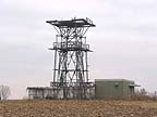
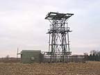
Chadwick's physical facilities consist of a self-supporting steel-lattice tower and an equipment building.
Thanks to Terry Michaels for contributing this information.
Chadwick was an auxiliary (relay) station on a four-hop microwave link (view additional details) from the Lee, IL main station to the Hanover, IL earth station (Hanover C.S.). From Lee, the hops to Dixon, Chadwick and Elizabeth used 4 GHz TD-3D equipment.
The link was brought on line around 1974, and retired in 1986. According to neighbors the 2 horn antennas aimed at Dixon on the 240 foot tower at Lee were removed by helicopter shortly thereafter. AT&T sold the towers and land at Dixon, Chadwick and Elizabeth in 1988. The earth station and the 11 GHz link tower were dismantled around 1994.
|
|
Created on January 2, 2003 at 18:47 by Albert LaFrance