Amarillo, TX
Information courtesy of Wayne Weishan
Amarillo was a microwave junction station and main station.
It is located on the north side of Amarillo at 505 NW 10th St., a couple of blocks north of Amarillo Blvd, and a few blocks west of Hwy 287.
To reach the station from I-40 take exit 70, head north on 87/287 about 2 mi., and turn west on Amarillo Blvd.
The property is bounded by N. Jackson St. on the east side, East St. on the west side, N.W. 10th St. on the north side and a junk yard to the south.
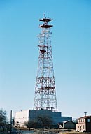
Amarillo's principal structures consist of a two-story building and a 237.5-foot type A-2P-SP steel-lattice tower.
The present building is an expansion of the original, much smaller TD-2 station.
The station's initial role was probably as the eastern terminal of the Amarillo - Albuquerque TD-2 (4 GHz band) route, which used delay-lens antennas.
A 1960 route map shows a second route, going north to Dodge City and on to Red Oak.
The station features two separate waveguide bridges; one ground-mounted and one at about the 25-foot level, probably routing waveguide to the north end of add-on second floor.
Open antenna positions suggest that the tower held at least ten horn-reflector antennas.
The base section is of the tower is 37.5 ft.; similar to Terrell, TX and typical of early TD-2 odd-increment tower construction.
The tower also has "ankle braces", probably required by the added outrigger platforms.
Amarillo is no longer in service as an AT&T communications facility, and all of its waveguides, combining networks and microwave antennas have been removed.
Windows Live Local offers a good aerial view of the site.
Images
Courtesy of Wayne Weishan
Select image to view a larger version

This view is from the north-northeast. |

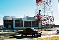
This is the west side of the facility.
The double doors open into a sparse 10 ft. by 12 ft. lime-green foyer with two doors on the opposite wall.
The left-hand door is marked AT&T entrance; the right-hand door is marked SW Bell Entrance. |

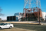
This is the tower yard viewed from the southwest.
Note the two-level waveguide support.
The lower waveguide runs north into what was probably part of original repeater building, and the upper waveguide support appears to run along the west side of the two-story expansion, with the waveguide hatchplate out of sight behind the AC facade.
The building addition is very close to the east tower face, probably because there's not a lot of real-estate on that side of the block.
Also note the different styles of combining network support frames.
The open-style framework was used in later construction after experience showed that the primary threat to combining networks was from directly above.
Even later construction eliminated the framework and used a single 7-inch square slotted pylon, the slot, of course, is to allow the long copper waveguide run to expand and contract relative to the steel tower yet retain precise alignment of the combining network stack relative to the horn azimuth. |

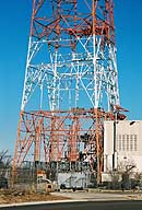
This view from the south-southeast gives an idea of how close the building addition is to the tower.
North Jackson St., on the east side of the property, is in the foreground. |
Return to...
Created on June 11, 2006 at 21:12 by Albert LaFrance


