

Address: Loudoun County, Virginia, on unnamed N-S road approximately 0.5 mi. E of the intersection of VA Rt. 650 (Gleedsville Rd.) and VA Rt. 771 (Woods Rd.)
Latitude: N39-02-30 (39.0417)
Longitude: W77-35-45 (-77.5958)
Elevation: 487 ft. (148 M)
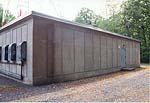
Aldie's 264-ft. "A-style" steel tower, painted in the traditional red and white and topped by a white strobe light, stands in sharp contrast to the surrounding heavily-wooded countryside. In addition to the tower, Aldie's facilities consist of a poured-concrete main building, and three smaller equipment buildings. One of these three is a vintage Western Electric factory-built shelter, constructed of natural-finish sheet metal riveted onto a supporting framework.
The tower holds two pairs of KS horns at the top, and two modern parabolic antennas mounted lower.
The three small shelters may be important clues to Aldie's history, as multiple equipment buildings are uncommon at AT&T microwave stations.
There is evidence of three past roles for Aldie:
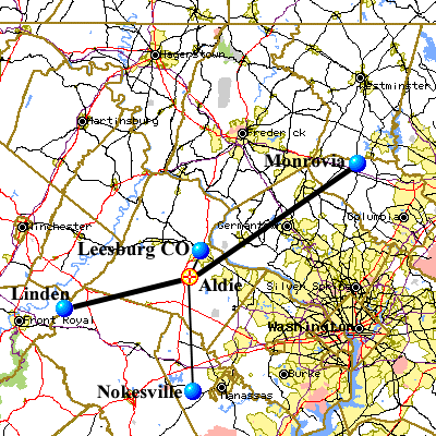
Aldie serves as relay point between the microwave stations at Linden (VA) and Monrovia (MD), under FCC callsign WMT368. It is a component of the microwave link between Monrovia and AT&T's EasyLink Services (tm) Message Operation Center in Middletown, VA. The likely purpose of this link is to connect Middletown into AT&T's fiber-optic cable network, since several AT&T cable routes converge at Monrovia.
Thick lines represent currently-licensed paths; thin lines show paths having canceled licenses.

Photographed May 3, 1998. Select images to view larger version.
Last Updated on July 9, 1999 at 00:44 by Albert LaFrance