| Entry | Title | Date | Description | |
|---|---|---|---|---|
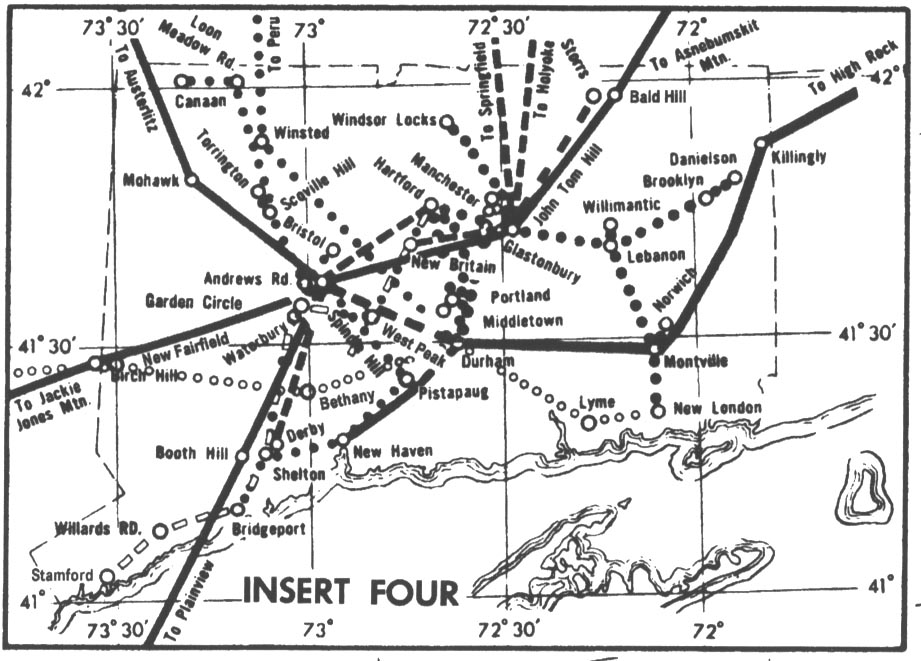
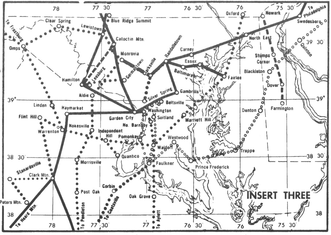
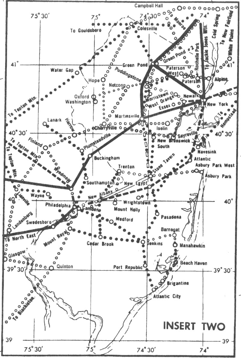
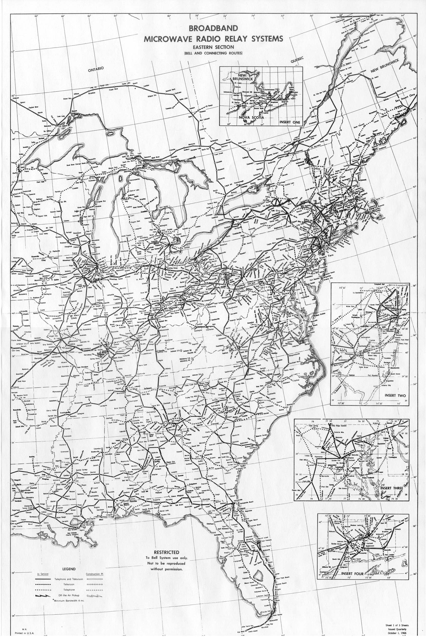
| 1 | Broadband Microwave Radio Relay Systems Eastern Section Bell and Connecting Routes |
Oct. 1, 1966 | 20" x 30", B&W photocopy Shows telephone, television, and combined routes, current and planned, U.S. and Canada. Approximate north latitudes - west longitudes of map corners are: NW: 52-90 NE: 50-66 SW: 26-92 SE: 26-74 Detailed insets cover: Connecticut Washington, DC region Philadelphia - New York City region New Brunswick and Nova Scotia View a reduced-size version. Extracts (8.5" x 11") from this map are posted in the Places and Routes section. |
|
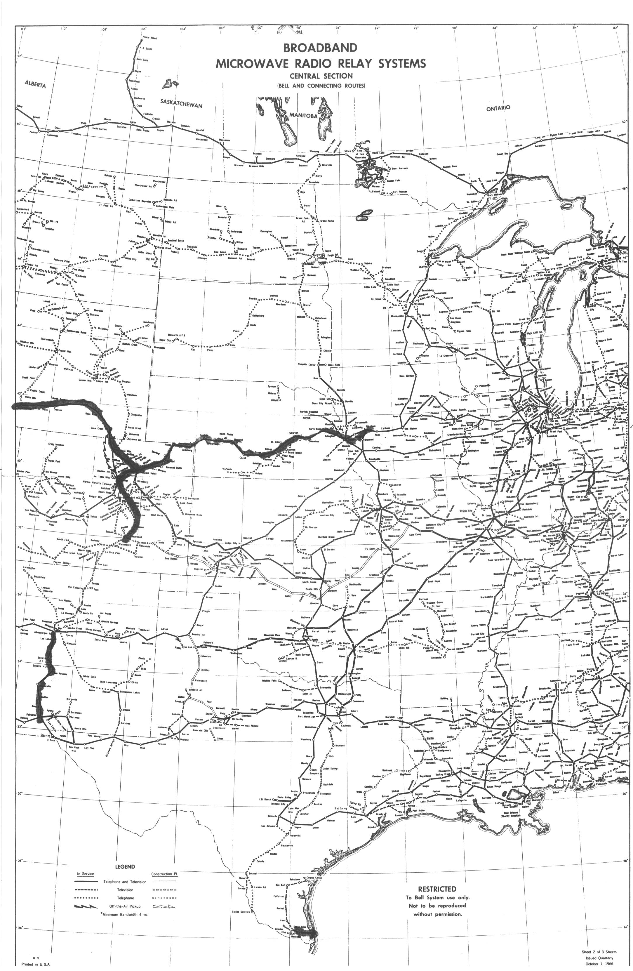
| 2 | Broadband Microwave Radio Relay Systems Central Section Bell and Connecting Routes |
Oct. 1, 1966 | 20" x 30", B&W photocopy Shows telephone, television, and combined routes, current and planned, U.S. and Canada. Approximate north latitudes - west longitudes of map corners are: NW: 52-112 NE: 52-82 SW: 26-106 SE: 26-88 View a reduced-size version. Extracts (8.5" x 11") from this map are posted in the Places and Routes section. |
|
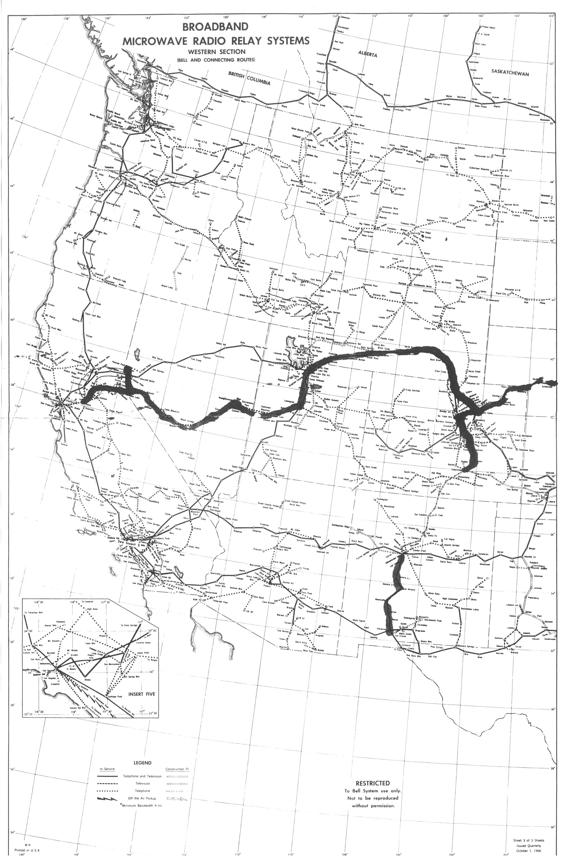
| 3 | Broadband Microwave Radio Relay Systems Western Section Bell and Connecting Routes |
Oct. 1, 1966 | 20" x 30", B&W photocopy Shows telephone, television, and combined routes, current and planned, U.S. and Canada. Approximate north latitudes - west longitudes of map corners are: NW: 48-130 NE: 52-102 SW: 24-120 SE: 26-102 Detailed inset covers Los Angeles region. View a reduced-size version. Extracts (8.5" x 11") from this map are posted in the Places and Routes section. |
|
| 4 | Routes of American Telephone and Telegraph Company Map. No. 6 |
Jan., 1970 | 32" x 21", B&W photocopy, shows:
| |
| 5 | Radio Relay Routes Long Lines Department Eastern Area FA-40845 |
Original: Jan. 20, 1976 Revised: Oct. 10, 1980 |
22" x 18", B&W photocopy Covers DC, DE, MD, PA, VA, WV and some stations in adjoining states. Shows existing and proposed routes (with numbers), and existing and proposed stations. Stations in "TH High Frequency Nationwide Transmit Plan" identified by unique symbols. Includes detailed insets for Washington and Pittsburgh areas. |
|
| 6 | Routes of American Telephone & Telegraph Co. Long Lines Department Central Area |
Jan., 1965 | 22" x 36", B&W photocopy Covers IL, IN, MI, OH and WI, and some stations in adjoining states, with detailed inset for Chicago. Shows microwave radio, coaxial cable, wire-pair cable and open wire routes. Includes lists of names of radio and cable routes. |
|
| 7 | Routes of American Telephone and Telegraph Company Long Lines Department Eastern Region |
Mar. 1979 | 28" x 22", B&W photocopy. Covers DC, DE, MD, PA, VA, WV and some stations in adjoining states, with detailed insets for coaxial-cable routes in DC and Philadelphia areas. Shows microwave radio, coaxial cable, and wire-pair cable routes, with high-capacity routes highlighted. Includes list titled "Official Names of Lines and Cables". | |
| 8 | Facility Routes of AT&T Eastern Region - South |
Printed: May 1987 Service as of: Dec. 1988 |
36" x 28", B&W photocopy of likely color-coded original. Covers DC, DE, MD, NJ, PA, VA, WV and some stations in adjoining states. Shows analog, digital, and special-construction radio and cable, fiber optics, leased facilities, and digits-on-coax"(P-140), but due to apparent use of color-coding on original which was removed in copying, only radio, cable (including fiber) or digits-on-coax route types can be distinguished. Also indicates owned, leased and switch POPs, and repeaters. |
Created on August 5, 2002 at 20:30 by Albert LaFrance