Images
Image courtesy of Eric Behr
Select image to view a larger version
Common Language Location Identifier (CLLI): unknown
Geolocation (GL) code: unknown
Address: on Diehl Rd. about 0.2 mi. E of Eola Rd. (CR-14), DuPage County, Illinois
Latitude: N41-47-58 (41.79937)
Longitude: W88-14-12 (-88.23654)
Elevation: unknown
Location: unknown
Active AT&T Callsigns: unknown
Canceled AT&T Callsigns: unknown
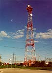
Eola's physical facilities consist of a self-supporting steel-lattice tower and an equipment building.
An October 1966 route map shows Eola as an apparent auxiliary (relay) station on a planned telephone-only (non-television) route between DeKalb, IL to the west-northwest and Lemont, IL to the southeast. A January 1970 map shows the route in service but does not specify the type of traffic carried. A 1979 map shows the same destinations, and possibly a path to Plato Center, IL.
|
Created on February 16, 2003 at 01:00 by Albert LaFrance